- ENGINE AND BOAT SALES
-
NAUTICAL PRODUCTS
- Inflatable boats
-
Boat Hardware
Boat Hardware
- Stainless steel cables accessories
- Clinometers
- Running Rigging Ropes
- Knives and accessories
- Sail Furlers
- Maintenance and repair
- Tiller brakes and extensions
- Wind indicators
- Fairleads and Eye Straps
- Shackles and Snap Hooks
- Blocks and organizers
- Tracks and travellers
- Turbuckles, Clevis and Cotter pins
- Spinaker poles and Bowsprits
- Cleats, Cam Cleats and Clutches
- Winches and accessories
- Mooring and docking
- Comfort
-
Electrical
Electrical
- Alternators and regulators
- Navigation light bulbs
- Marine Batteries, selectors and monitors
- Shore power cords and power inlets
- Wire and battery terminals
- Electrical Distribution
- Marine Navigation lights
- Tinned Wires 12V and 120V
- Inverters and chargers
- Exterior lighting and spotlights
- Interior lighting
- Solar Panels and Fuel Cells
-
Electronics
Electronics
- GPS, Multifonction Network displays and Chartplotters
- VHF and TV antennas
- NMEA 2000 Network and Cables
- Electronic charts and softwares
- Navigation instruments, Depth, Speed and Wind
- Fishing Trolling Motor
- Cockpit Autopilots
- Below deck autopilots
- Radars
- Fixed mount VHF radio
- Handheld VHF radio
- Transducers depth and fishing
- Sound systems and speakers
- AIS transponders and receivers
-
Maintenance
Maintenance
- Finishing and antifoulling paints
- Non Skid Paint and Anti-Slip Deck Covering
- Epoxy Resins and fiber accessories
- Marine cleaners
- Waterproofing and Treatment Products
- Finishing compounds and waxes
- Varnish, Teak Oil and Teak Cleaner
- Gelcoat restoration
- Sealants and adhesives
- Painting and Maintenance Supplies
- Synthetic deck
- Engine
- Navigation
- Plumbing
- Hardware
- Safety
- Sports and Entertainment
- Marine Clothing
- WATERSPORT STORE
- MARINE CLOTHING
- BLYACHT STORE
- SALES & NEW PRODUCTS
- LIQUIDATIONS
- Boulet Lemelin Yacht>
- Catalog>
- Electronics>
- Electronic charts and softwares>
- NAVIONICS+ Lakes, Rivers and Coastal Marine Charts (CANADA-ALASKA)
")
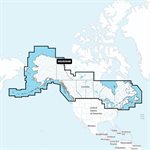
NAVIONICS+ Lakes, Rivers and Coastal Marine Charts (CANADA-ALASKA)
Product Code: 0228820
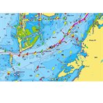
Featuring vibrant colors, a streamlined interface and combined coastal/inland content with a popular Navionics style color palette, Garmin Navionics+ cartography makes it easy to plot your course with the world’s No. 1 name in marine mapping.
Features:
Navionics advanced dock-to-dock route guidance technology uses your boat settings, along with chart data and frequently traveled routes, to calculate a suggested path to follow.
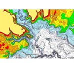
Improved fishing and navigation, SonarChart™ HD bathymetry maps display up to 1’ (0.5 meters) contours, providing a more detailed depiction of the bottom structure
Fishing range advanced feature lets you highlight a user-defined target depth range.
SonarChart Live mapping feature allows boaters to create new personal 1’ HD bathymetry maps that display in real time on the screens of their compatible plotters while navigating
Compatibility:
Echomap UHD (7/9)
Echomap Ultra (10/12)
GPSmap 10X2/12X2)
GPSmap 12X2 Touch
GPSmap 7X2, 9X2, 12X2 Plus
GPSmap 7X3/9X3/12X3
GPSmap 8400/8600
GPSmap 8700 Black Box
- Availability:
Special Order, Call us!