Chart SD/Micro SD format
Provides detailed coverage of the eastern coast of the U.S. from Key West, FL to the Canadian border and the western coast from the Mexican border to Puget Sound, Alaska, Hawaii and major inland rivers, the U.S. Gulf Coast to the Mexican border and the Mexican Gulf Coast thru to the Yucatan. Canadian coverage includes the entire St. Lawrence Seaway, Nova Scotia and New Brunswick. The Great Lakes are covered in their entirety as are the Lake of the Woods. Coverage includes Prince Edward Island, Anticosti Island, Vancouver Island including the Inside and Outside Passages, Aleutian and Channel Islands, Bahamas, Turks and Caicos Islands, Cozumel, Cuba, Hispaniola, Puerto Rico and the U.S. Virgin Islands.
Version Enhancements:
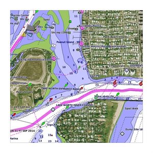
See your vessel’s precise, on-chart position in relation to navaids, coastal features, anchorages, obstructions, waterways, restricted areas and more with this detailed marine mapping data.
• Shaded depth contours, coastlines, spot soundings, navaids, port plans, wrecks, obstructions, intertidal zones, restricted areas and IALA symbols.
• Seamless transitions between zoom levels and more continuity across chart boundaries.
• Standard 2-D direct overhead or 3-D “over the bow” map perspective for easy chart reading and orientation.
• Safety Shading* enables contour shading for all depth contours shallower than your defined safe depths.
• Fishing Charts* to scope out bottom contours and depth soundings with less visual clutter on the display.
• Features up to 1-foot HD fishing contours which reveal detailed seafloor terrain.
• Plan and organize routes from your computer with HomePort™ (sold separately).
See your vessel’s precise position on-chart in relation to navaids, spot soundings, coastal features, anchorages, port plans, waterways, obstructions, restricted areas and more. BlueChart® g2 HD provides seamless chart presentation with 1-foot HD contours to provide a more accurate depiction of bottom structure for improved fishing charts and navigation in swamps, canals, marinas and port plans.
In addition to the basic charts, tidal stations, currents, depth contours, IALA symbols and included full bathymetric fishing charts with detailed contours, BlueChart g2 HD also offers smooth transitioning between zoom levels and seamless continuity across chart boundaries.
Customize Your Screens
BlueChart g2 HD also adds Shallow Water Shading to allow the user to enable contour shading for all depth contours shallower than the user-defined safe depth.
The fishing charts are designed to emphasize bathymetric contours with less visual clutter on the display.
There’s also a choice of standard 2-D direct overhead or 3-D “over-the-bow” map views for easier chart reading and orientation.
Detailed harbor information including lights, navigation lines, and tidal information show you the way home.
Fishing contours allow the user to have a clearer view of the ocean floor to catch more fish.