- ENGINE AND BOAT SALES
-
NAUTICAL PRODUCTS
- Inflatable boats
-
Boat Hardware
Boat Hardware
- Stainless steel cables accessories
- Clinometers
- Running Rigging Ropes
- Knives and accessories
- Sail Furlers
- Maintenance and repair
- Tiller brakes and extensions
- Wind indicators
- Fairleads and Eye Straps
- Shackles and Snap Hooks
- Blocks and organizers
- Tracks and travellers
- Turbuckles, Clevis and Cotter pins
- Spinaker poles and Bowsprits
- Cleats, Cam Cleats and Clutches
- Winches and accessories
- Mooring and docking
- Comfort
-
Electrical
Electrical
- Alternators and regulators
- Navigation light bulbs
- Marine Batteries, selectors and monitors
- Shore power cords and power inlets
- Wire and battery terminals
- Electrical Distribution
- Marine Navigation lights
- Tinned Wires 12V and 120V
- Inverters and chargers
- Exterior lighting and spotlights
- Interior lighting
- Solar Panels and Fuel Cells
-
Electronics
Electronics
- GPS, Multifonction Network displays and Chartplotters
- VHF and TV antennas
- NMEA 2000 Network and Cables
- Electronic charts and softwares
- Navigation instruments, Depth, Speed and Wind
- Fishing Trolling Motor
- Cockpit Autopilots
- Below deck autopilots
- Radars
- Fixed mount VHF radio
- Handheld VHF radio
- Transducers depth and fishing
- Sound systems and speakers
- AIS transponders and receivers
-
Maintenance
Maintenance
- Finishing and antifoulling paints
- Non Skid Paint and Anti-Slip Deck Covering
- Epoxy Resins and fiber accessories
- Marine cleaners
- Waterproofing and Treatment Products
- Finishing compounds and waxes
- Varnish, Teak Oil and Teak Cleaner
- Gelcoat restoration
- Sealants and adhesives
- Painting and Maintenance Supplies
- Synthetic deck
- Engine
- Navigation
- Plumbing
- Hardware
- Safety
- Sports and Entertainment
- Marine Clothing
- WATERSPORT STORE
- MARINE CLOTHING
- BLYACHT STORE
- SALES & NEW PRODUCTS
- LIQUIDATIONS
- Boulet Lemelin Yacht>
- Catalog>
- Electronics>
- Electronic charts and softwares>
- Garmin LakeVü g3 Ultra Canada

Garmin LakeVü g3 Ultra Canada
Product Code: 0209448.UL
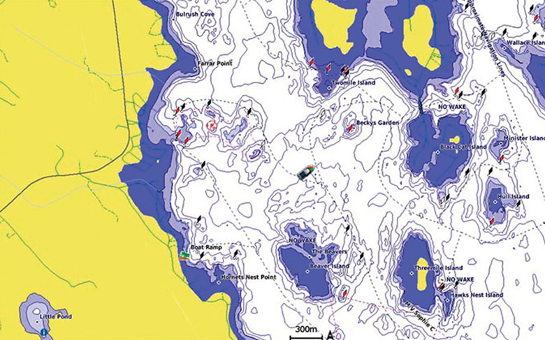
The Premier Freshwater Fishing Map
- Industry-leading coverage, clarity and detail with updated inland maps that feature integrated Garmin and Navionics® content
- Coverage for more than 13,500 total lakes, of which more than 4,800 have up to 1’ contours
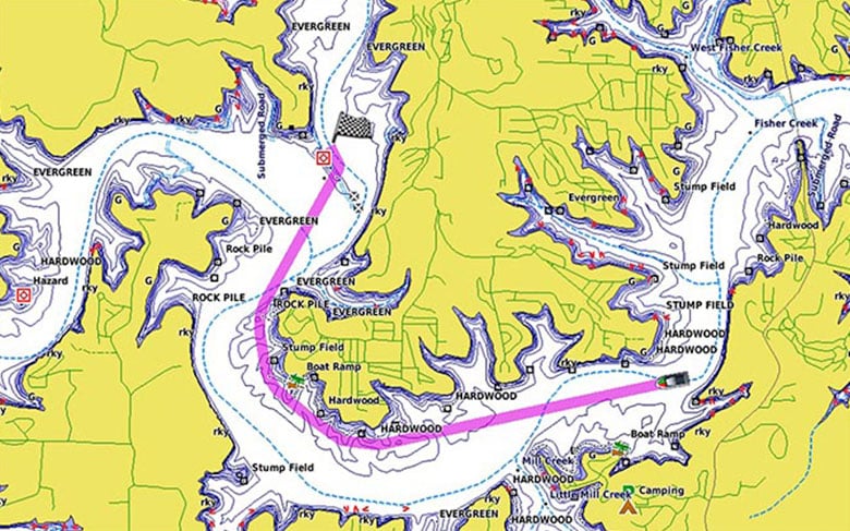
- Auto Guidance¹ technology quickly calculates a suggested route by using your desired depth and overhead clearance
- High-resolution Relief Shading makes it easier to see contours and find fish holding structure
- Depth Range Shading for up to 10 depth ranges enables you to view your target depth at a glance
Experience unparalleled coverage and brilliant detail when you’re on the water. Canada LakeVü g3 Ultra inland maps provide industry-leading coverage, clarity and detail with integrated Garmin and Navionics content.
Auto Guidance
Whether you are fishing or cruising, select a spot, and get a route showing you the general path and nearby obstructions at a safe depth¹.
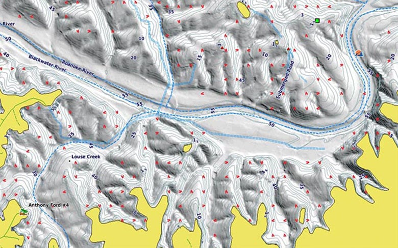
High-resolution Relief Shading
The High-resolution Relief Shading feature adds visual depth to the 2-D map, making it easier to interpret contours and find fish holding structure.
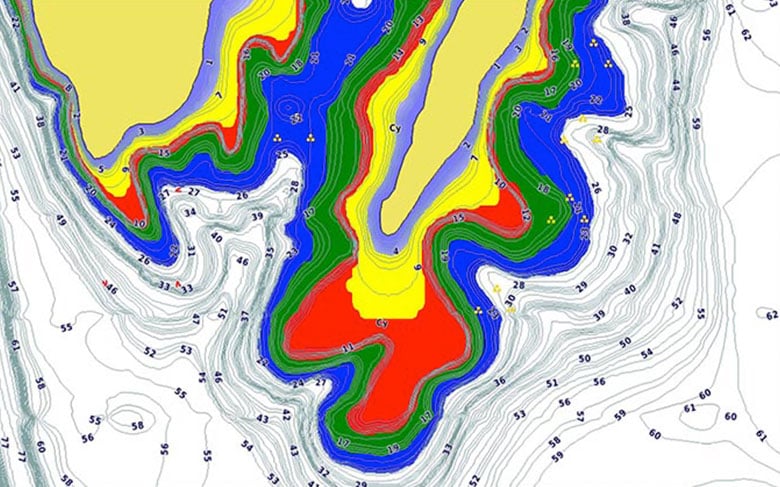
Depth Range Shading
This feature displays high-resolution Depth Range Shading for up to 10 depth ranges so you can view your designated target depth.
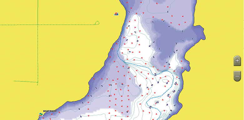
Shallow Water Shading
To give a clear picture of shallow waters to avoid, this feature allows for shading at a user-defined depth.
Dynamic Lake Level
This feature allows you to adjust your maps to the lake’s current water levels, giving you a better idea of spots that are either accessible or too shallow to explore.
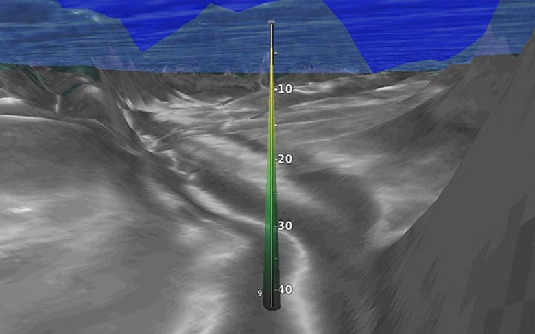
FishEye View
This underwater perspective shows 3-D representation of lake bottom and contours as seen from below the waterline. Interface with sonar data for a customized view.
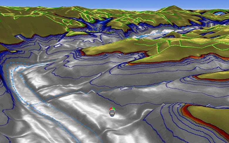
MarinerEye View
This view provides a 3-D representation of the surrounding area both above and below the waterline.
Access Your Charts and Maps
Download the ActiveCaptain® app to use OneChart™, which gives you access to all your charts and maps from your mobile device and even lets you purchase new ones.
¹Auto Guidance is for planning purposes only and does not replace safe navigation practices
- Availability:
Special Order, Call us!
- Manufacturer's number : 010-C1114-00
- Model : LakeVü g3 Ultra 2016