- ENGINE AND BOAT SALES
-
NAUTICAL PRODUCTS
- Inflatable boats
-
Boat Hardware
Boat Hardware
- Blocks and organizers
- Cleats, Cam Cleats and Clutches
- Clinometers
- Fairleads and Eye Straps
- Knives and accessories
- Maintenance and repair
- Running Rigging Ropes
- Sail Furlers
- Shackles and Snap Hooks
- Spinaker poles and Bowsprits
- Stainless steel cables accessories
- Tiller brakes and extensions
- Tracks and travellers
- Turbuckles, Clevis and Cotter pins
- Winches and accessories
- Wind indicators
- Comfort
-
Electrical
Electrical
- Alternators and regulators
- Electrical Distribution
- Exterior lighting and spotlights
- Interior lighting
- Inverters and chargers
- Marine Batteries, selectors and monitors
- Marine Navigation lights
- Navigation light bulbs
- Shore power cords and power inlets
- Solar Panels and Fuel Cells
- Tinned Wires 12V and 120V
- Wire and battery terminals
-
Electronics
Electronics
- GPS, Multifonction Network displays and Chartplotters
- AIS transponders and receivers
- Below deck autopilots
- Cockpit Autopilots
- Electronic charts and softwares
- Fishing Trolling Motor
- Fixed mount VHF radio
- Handheld VHF radio
- Navigation instruments, Depth, Speed and Wind
- NMEA 2000 Network and Cables
- Radars
- Sound systems and speakers
- Transducers depth and fishing
- VHF and TV antennas
- Engine
- Hardware
-
Maintenance
Maintenance
- Finishing and antifoulling paints
- Non Skid Paint and Anti-Slip Deck Covering
- Epoxy Resins and fiber accessories
- Marine cleaners
- Waterproofing and Treatment Products
- Finishing compounds and waxes
- Varnish, Teak Oil and Teak Cleaner
- Gelcoat restoration
- Sealants and adhesives
- Painting and Maintenance Supplies
- Synthetic deck
- Marine Clothing
- Mooring and docking
- Navigation
- Plumbing
- Safety
- Sports and Entertainment
- WATERSPORT STORE
- MARINE CLOTHING
- BLYACHT STORE
- SALES - NEW PRODUCTS
- LIQUIDATIONS
- Boulet Lemelin Yacht>
- Catalog>
- Electronics>
- Electronic charts and softwares>
- Garmin Bluechart g3 Vision ( Gulf of St. Lawrence River-Les Mechins to St. George's Bay)
")
Garmin Bluechart g3 Vision ( Gulf of St. Lawrence River-Les Mechins to St. George's Bay)
Product Code: 0201458.VCA07
Bluechart g3 Vision Color vector charts on pre-programmed SD/Micro SD data cards with high-resolution satellite imagery, 3D views, photos and many details. Gulf of St-Lawrence River card from Les Mechins to St. George's Bay
Premium mapping and graphics capabilities
- Detailed nautical charts, in vector object oriented format, derived from government charts and private sources to provide port plans, depth contours, navigational aids, and tides and currents in a seamless chart presentation
- Shaded depth contours and intertidal zones with spot soundings
- Aerial photos of ports, marinas, bridges and navigational landmarks and realistic “view from space” high-resolution satellite imagery
- Up to 1-foot HD contours provide a more accurate depiction of bottom structure for improved fishing charts and navigation in swamps, canals, marinas and port plans
- Patented Garmin Auto Guidance 3.0 technology is now capable of providing routing guidance¹ to virtually any accessible destination on the water
- Worldwide coverage available in regionalized cuts
Based on the standard BlueChart® g3 features, BlueChart g3 Vision provides premium mapping and graphics capabilities. Plug a BlueChart g3 Vision card into your compatible chartplotter's microSD™/SD™ card slot to tremendously expand its mapping capabilities.
BlueChart g3 Vision is our premium marine cartography for use with Garmin chartplotters. It includes all the features of BlueChart g3 charts and adds Garmin exclusive Auto Guidance 3.0. Garmin Auto Guidance 3.0 technology quickly searches relevant charts to suggest a course according to your boat’s dimensions and creates a visual path that seeks to avoid low bridges, shallow water and other charted obstructions. With version 3.0, Auto Guidance can guide the user and in and out of more places more effectively, including entering and exiting marinas.¹
BlueChart g3 Vision features seamless chart presentation with 1-foot HD contours that provide a more accurate depiction of bottom structure for improved fishing charts and enhanced detail in swamps, canals and port plans. It also provides enhanced labeling for more coastal cities and ports.
In addition to highly detailed nautical chart data, BlueChart g3 Vision also adds 3-D above and below the waterline, aerial photos, satellite imagery and coastal roads as well as points of interest.
Plug a BlueChart g3 Vision card into your compatible chartplotter's SD card slot and you will tremendously expand its charting capabilities.
Enter the World of Auto Guidance 3.0
By adding a BlueChart g3 Vision card to your compatible chartplotter, you can take advantage of patented Garmin Auto Guidance 3.0 technology. Enter the location where you want to go and Auto Guidance 3.0 instantly searches through relevant charts to create a path specifically designed for the dimensions of your boat. Auto Guidance provides a visual path that seeks to avoid low bridges, shallow water and other charted obstructions. But it also provides navigational solutions, such as entering and exiting marinas.¹ When Auto Guidance 3.0 is coupled with a Garmin autopilot system, you can engage your compatible autopilot to follow the Auto Guidance route, and it will keep you on route, automatically.
Enhance Your Vision
High-resolution satellite imagery enhances chart depictions for superior situational awareness so you can navigate with a clear moving-map representation of your boat’s position. It's our most realistic mapping display in a chartplotter.
Auto Guidance 3.0 searches though all relevant charts to create a route that seeks to avoid obstacles, shallow water, buoys and other obstructions.¹
High resolution imagery with navigational charts overlaid gives you a realistic view of your surroundings.
Crystal clear aerial photography shows exceptional detail of many ports, harbors and marinas.
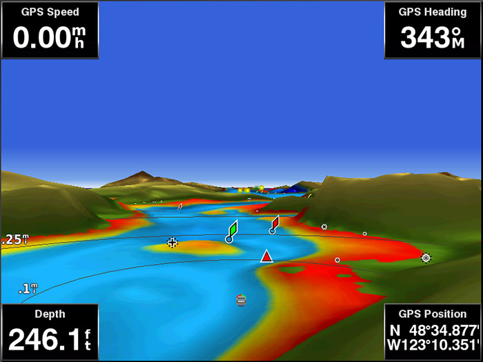
MarinerEye view provides a 3-D representation of the surrounding area both above and below the waterline.
FishEye view provides a 3-D representation of the ocean floor as seen from below the waterline.
Get the Best View
BlueChart g3Vision data lets you select true 3-D MarinerEye view or FishEye view perspective for dynamic views both above and below the waterline. Auto Guidance 3.0 technology suggests the best routes to follow. Aerial photos of ports, harbors, marinas, waterways and coastal roads help you see "the big picture" when you’re on the water.
- Manufacturer's number : 010-C0693-00
- Area : Gulf St-Laurent